


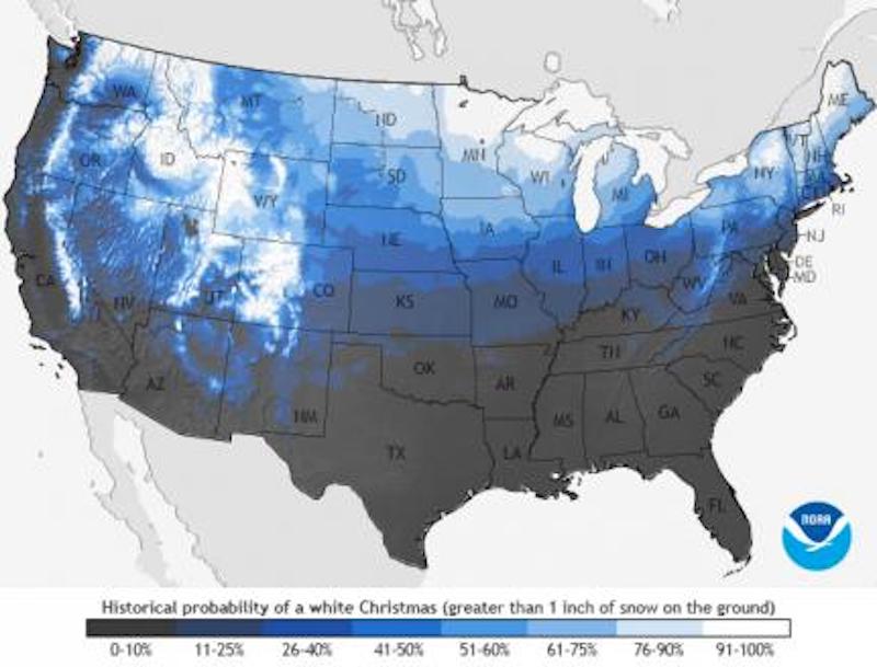
If you live in the U.S. and are wondering about your chances of getting a white Christmas this year, here’s a map that’ll help you determine the probability that your hometown will have snow on the ground on Christmas Day 2020.
The so-called “Historical Probability of a White Christmas” map shows the probability of at least 1 inch of snow being on the ground on December 25 in the contiguous United States. NOAA (National Oceanic and Atmospheric Administration) released this year’s map, based on 30 years of weather data, on December 7, 2020. You can click on your hometown on this interactive version of the map.
The 2021 lunar calendars are here! Order yours before they’re gone. Makes a great gift!
Here are the places that NOAA says have the best chances for a white Christmas in the Lower 48 in 2020:
Most of Idaho, Minnesota, Maine, Upstate New York, the Allegheny Mountains of Pennsylvania and West Virginia, and, of course, the Rockies and the Sierra Nevada Mountains all have a high probability of seeing a white Christmas. And, Aspen, Colorado, is just one of about a dozen locations boasting a 100% historical probability of seeing a white Christmas.
This map is based on the 1981-2010 Climate Normals, which are the latest three-decade averages of several climatological measurements. NOAA said:
This dataset contains daily and monthly Normals of temperature, precipitation, snowfall, heating and cooling degree days, frost/freeze dates, and growing degree days calculated from observations at approximately 9,800 stations operated by NOAA’s National Weather Service.
NOAA added that while the map shows the climatological probability of snow-covered ground on December 25, the actual conditions this year may vary widely from these probabilities because the weather patterns present at the time will determine if there is snow on the ground or if snow will fall on Christmas Day. For prediction of your actual weather conditions, check out your local forecast at Weather.gov within seven days of Christmas.
Bottom line: NOAA map of the U.S. depicting chances of a white Christmas in 2020.
Source: White Christmas? An Application of NOAA’s 1981–2010 Daily Normals>
Like what you read?
Subscribe and receive daily news delivered to your inbox.
More from
Eleanor Imster


